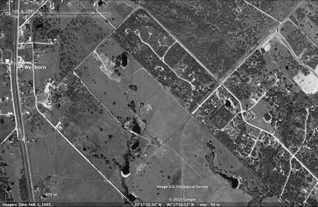
The original Greens Prairie Rd. was in two segments: Greens Prairie Rd. W went from Wellborn, Texas (at an intersection) to Woodlake Rd., where it intersected with Greens Prairie Rd. which went extended slightly to the southwest.
From there, the two-way road (with asphalt and tar) went up to the highway and extended only mainly enough to the new exurban Pebble Creek subdivision.
Past that was literally to the dump at Rock Prairie Road (which didn't connect to the "current" Rock Prairie Road).
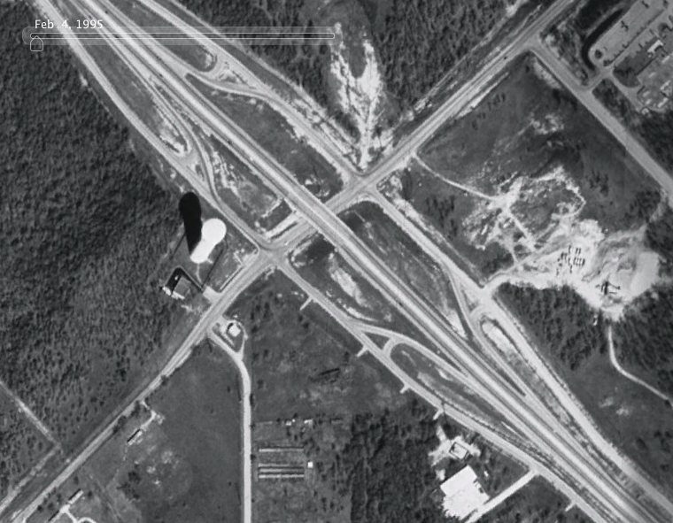
The water tower that was there (I don't know when it was built) was a reminder to travelers going north that the worst was over: no longer did they have to travel on the "highway of death" (SH-6 south), or, prior to 1996, the two-way highway extending out of Houston. Travelers were entering College Station-Bryan, for the next 13 exits (not counting the Texas Avenue exit).
Of course, that was the 1990s.
As College Station expanded, the corridor at Rock Prairie really started to take off, starting with a new 5th-and-6th grade campus called Cypress Grove Intermediate School off the mostly-rural road South Graham Road in 1999, and a large Kroger-anchored center in 2000. Greens Prairie even got an extension, which led Greens Prairie in one unbroken road to even more south on Wellborn Road (albeit dubbed "Greens Prairie Trail")
Even then, the Greens Prairie overpass was fairly rural, but as Pebble Creek started to expand, other subdivisions took off in the area. When a combo McDonald's/Exxon opened in the early 2000s (or late 1990s) it was still a little odd to see way out in the boonies. But plans were in the works to bring a huge state highway down from South Graham (soon to be known as simply Graham Road) down to Greens Prairie.
Meanwhile, Greens Prairie itself was having problems. During rush hour, traffic backed up from the two-way frontage roads onto the highway.
But the new highway promise would change everything: around 2001, Greens Prairie extended from Rock Prairie all the way to Highway 30, then Greens Prairie four-laned from the highway to Pebble Creek, and eventually the overpass was rebuilt and expanded. The frontage roads were made one-way and widened, turnaround lanes were added, the exit/entrance lanes were pushed back about a mile, and Greens Prairie widened out (reportedly, the original overpass had a lot of graffiti)
Forest Ridge Elementary, the sixth elementary school in the district, opened in 2005. But the highway was to occupy the current Greens Prairie Rd., so Greens Prairie had to be rerouted around to a new road called Arrington Rd. (the older Arrington was renamed Old Arrington, even though the new Arrington never extended for years).

Here is Greens Prairie near the highway as it appeared in 2005, courtesy the 2005 annual report of College Station. Greens Prairie temporarily got direct access to the new highway as the main segment was rerouted to Arrington. Eventually, Greens Prairie would terminate at Arrington.
I remember in 2006 that the stoplights at the highway said that the segment to the east was still Greens Prairie Rd. E., and the other direction was SH-40. The city had a "naming contest" about that time. The name that most people sent in was Billy Gillispie, the Texas A&M University basketball coach who turned the losing men's basketball team around. But the city council decided on naming it after a man who developed much of College Station, naming the highway (and Greens Prairie Rd. E.) as William D. Fitch Parkway in August 2006. Coincidentally, Gillespie resigned from his post in early 2007, so it was probably for the better.
Since the opening of the new road, William D. Fitch Parkway suffered a major accident (a teenager ran the stop sign at Barron Road), two stoplights (Arrington and Lakeway, with one opening in 2009, the other in 2010), widened past Pebble Creek (2010, all the way past Rock Prairie) and new businesses (Tower Point, which features H-E-B and other stores that have already been seen in the area; Caprock Crossing, which features a small strip center and a Walgreens, and Spring Creek Village on the other side).
The Lowe's is the anchor of "Spring Creek Village", which (currently) features a Lowe's, Chick-fil-A, a small strip center under construction (a mattress shop and a CiCi's) and Whataburger, wrapping around a gas station with an empty restaurant pad. Great to learn that College Station finally has its first Lowe's, after Bryan having one for years and years.
That's not entirely true, we did get a Lowe's back in the mid-1980s, on the bypass.
At about the time Boonville Station was on the table (as mentioned above), a much grander plan was on the table for south College Station. Rather than Spring Creek Village, this bit from the 2004 Annual Report states that "Quorum Equities of Dallas will develop a $10 million retail center at the northeast corner of Greens Prairie Road and State Highway 6. The development will encompass approximately 300,000 square feet of retail and restaurant uses, making it the largest outdoor retail center in College Station."
While 300,000 is pretty small: the "Central Texas Marketplace" in Waco is an outdoor center but around 700,000 square feet, the mall is about 800,000, and even the local Walmart caps at around 250,000, it would be large enough for a big store, like, say, a Target, a handful of smaller stores (Best Buy, Old Navy) and plenty of small stores and restaurants. But somewhere along the lines, a St. Joseph Express opened, and it was scaled down to a Lowe's, four fast food restaurants (two of which have been built), a bank, and a pharmacy. It was modified slightly from the original plan. It was also by a different developer, though this picture from the current Spring Creek Village indicates that there COULD be a possible second major store, but St. Joe's tends to hem it in so it's not possible.

Perhaps it was best that the 300,000 square feet couldn't take off...there are at least two major strip centers that have huge undeveloped retail swaths (University Town Center, Bryan Towne Center). Anyway, the Lowe's opened in fall 2010, which means that Quorum abandoned plans at some point in the past. In any case, College Station has a Lowe's again, and the original Lowe's is now a place to play glow-in-the-dark mini-golf, which is the result today.
Meanwhile, Greens Prairie got a load of new upper-end subdivisions, but part of it is still rural, and a 2013 expansion led the road out to the highway once more, as part of the development of Caprock Crossing. Unfortunately, at the highway, you can only go left or right, not straight.
 One more story to tell. The Exxon was the first thing at the interchange besides the water tower. It featured a McDonald's, which was no bigger than a walk-up and about a dozen or so seats. Back when it was built in the late 1990s (but Brazos CAD says 2001, something I find still too late), the area was largely wilderness, and just inside the city limits. There was Pebble Creek, the water tower, and two-way frontage roads, then Nantucket, then Texas World Speedway. There was literally nothing in that direction, and to me reaching that McDonald's was an adventure, as passing that McDonald's meant heading out of town, and no signs of civilization until maybe Navasota. Well, the rebuilding of the frontage lanes and the new Highway 40 circa 2004-2005 changed the access of the McDonald's. You couldn't turn left in or out of it onto William D. Fitch, and the frontage lanes were one way.
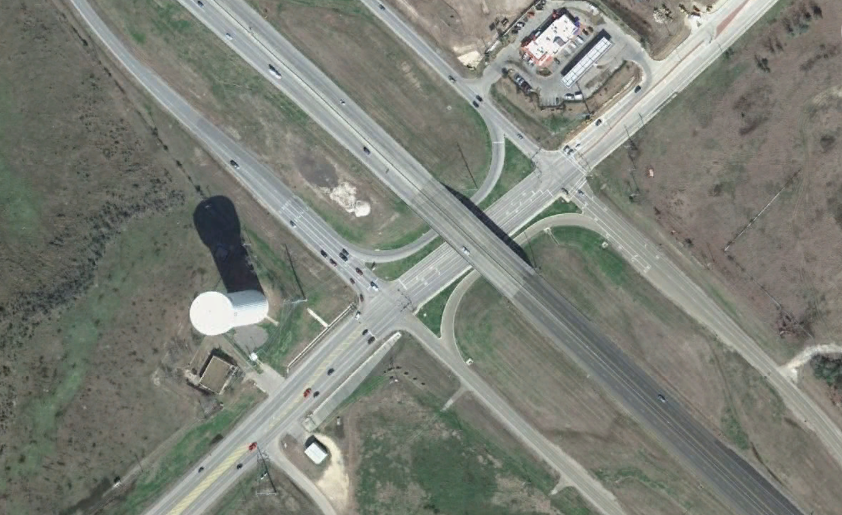
Eventually, this problem was pacified with the Lakeway stoplight and extension, but the McDonald's moved on in 2012, opting for a pad with the newer design (no mansard roof) on the other side of the highway. Not to worry: that side of the highway would gain Chick-fil-A and Whataburger by that point. Despite the changes in and around the area, it still stood as a familiar landmark. The address also changed, the Exxon was originally a 103 Greens Prairie Road, that later became 1103 Greens Prairie Road.
After the move to Tower Point, the golden arches were initially covered up with a tarp, and eventually removed entirely. The actual pad was covered with brown shingles like how Taco Bell used to have (so now it looks like an old Taco Bell). What will go in there? No one knows, but we can keep dreaming.
Click the pictures for higher resolution. Please email any comments to Pseudo3D at EARTHBOUNDMAN AT GMAIL DOT COM.
6/25/14: Copied from old blog, made some updates and changes for HTML.
Back to On the Road
Back to Brazos Buildings & Businesses